


Update: Vincent Thomas Bridge Closures
Updated: Jun 25

Date: June 24, 2026 District: 7, Los Angeles and Ventura Counties Contact: Nathan Bass Upcoming Partial Closures of Ferry Street and Harbor Boulevard in San Pedro Work will occur during scheduled overnight westbound or eastbound Vincent Thomas Bridge closures SAN PEDRO — Caltrans (District 7) will continue overnight single-lane closures on Ferry Street and Harbor Boulevard in San Pedro beginning Wednesday night, June 24. Closures will occur nightly from 8 p.m. to 6:45 a.m. to allow for the installation of protective shielding. Work will occur on Ferry Street near State Route 47 (SR-47) and on Harbor Boulevard near Front Street. During Harbor Boulevard closures, one lane will remain open and be configured to maintain two-way traffic. During Ferry Street one-lane closures, traffic will be diverted to northbound SR-47 and Ferry Street, since the southbound SR-47 on-ramp will be closed. The schedule of closures is as follows:
This work is part of the Vincent Thomas Bridge Deck Replacement Project. A critical infrastructure project totaling $752.8 million, the deck replacement will require partial and full closures of the bridge over the next two years. More information is available at the project website. Skanska-CEC Joint Venture is the general contractor for the project.
Due to weather or operational factors, the schedule is subject to change, including dates and times, the number of closures, and other details. Motorists should expect delays when utilizing the Vincent Thomas Bridge and use Caltrans Quickmap to review current traffic conditions before traveling. Caltrans reminds drivers to exercise increased caution near the closure and Slow for the Cone Zone. |
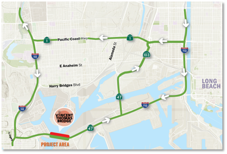
See below for map showing the detour route for westbound overnight closures.


Comments